Intermap Technologies has announced at the ESRI International User Conference the full commercial availability of its NEXTMap USA countrywide digital mapping program.
Uniformly accurate digital elevation models and images for the contiguous U.S. and Hawaii (approximately 8 million square kilometers) are now available via the company's Open Geospatial Consortium (OGC)-based cloud computing platform, TerrainOnDemand, and its worldwide network of distributors and strategic partners.
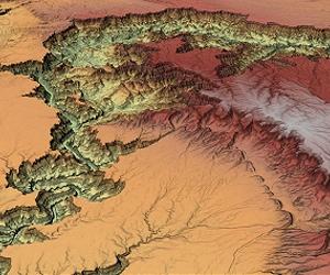
The NEXTMap USA dataset features digital surface models (DSMs) that include cultural features (such as vegetation, buildings, and roads), digital terrain models (DTMs) that display the bare earth (with cultural features digitally removed), orthorectified radar images (ORIs) corrected to remove normal geometric distortions (grayscale images that accentuate topographic features), elevation shaded images (ESIs) that are multi-spectral images (derived from NEXTMap data and high-resolution images) along with a variety of other geospatial products.
NEXTMap USA joins Intermap's NEXTMap Europe dataset for all of Western Europe (2.4 million square kilometers) and other regions already in the company's extensive geospatial data library, totaling more than 12.5 million square kilometers of available data.
"NEXTMap USA is the only uniformly accurate high-resolution elevation map available that covers the 48 contiguous states and Hawaii," said Brian Bullock, Intermap's president and CEO.
"This high-resolution wide-area digital map data provides an affordable and reliable option for GIS professionals. NEXTMap USA also enables better business decisions by providing a cost-efficient solution that is ideally suited for any geospatial project requiring uniform and seamless elevation data across wide areas. The fact that our product is immediately available, accurate enough for a wide variety of geospatial projects, and can be easily integrated with existing NED or LiDAR data as project requirements dictate, provides tremendous value to government agencies and commercial enterprises worldwide."
Data collected as part of the Company's NEXTMap countrywide global mapping programs enables a variety of geospatial applications and prototyping endeavors worldwide.
Applications include, but are not limited to, route and site selection, cell tower placement, engineering planning, transportation safety and fuel efficiency, water resource management, insurance risk assessment, oil and gas planning and exploration, and 3D visualization.
Share This Article With Planet Earth
